LIVE WEATHER-TRAFFIC: Thunderstorm warnings expire in North Georgia; lighter rain continues
ATLANTA FORECAST
Friday: High: 88
Friday night: Low: 72
Saturday: High: 88
» For a detailed forecast, visit The Atlanta Journal-Constitution weather page.
[8:15 p.m.]: The NWS thunderstorm warnings across metro Atlanta have expired. A few thunderstorm warnings continue in Middle Georgia, including Chattahoochee, Harris and Muscogee counties until 8:30 p.m.
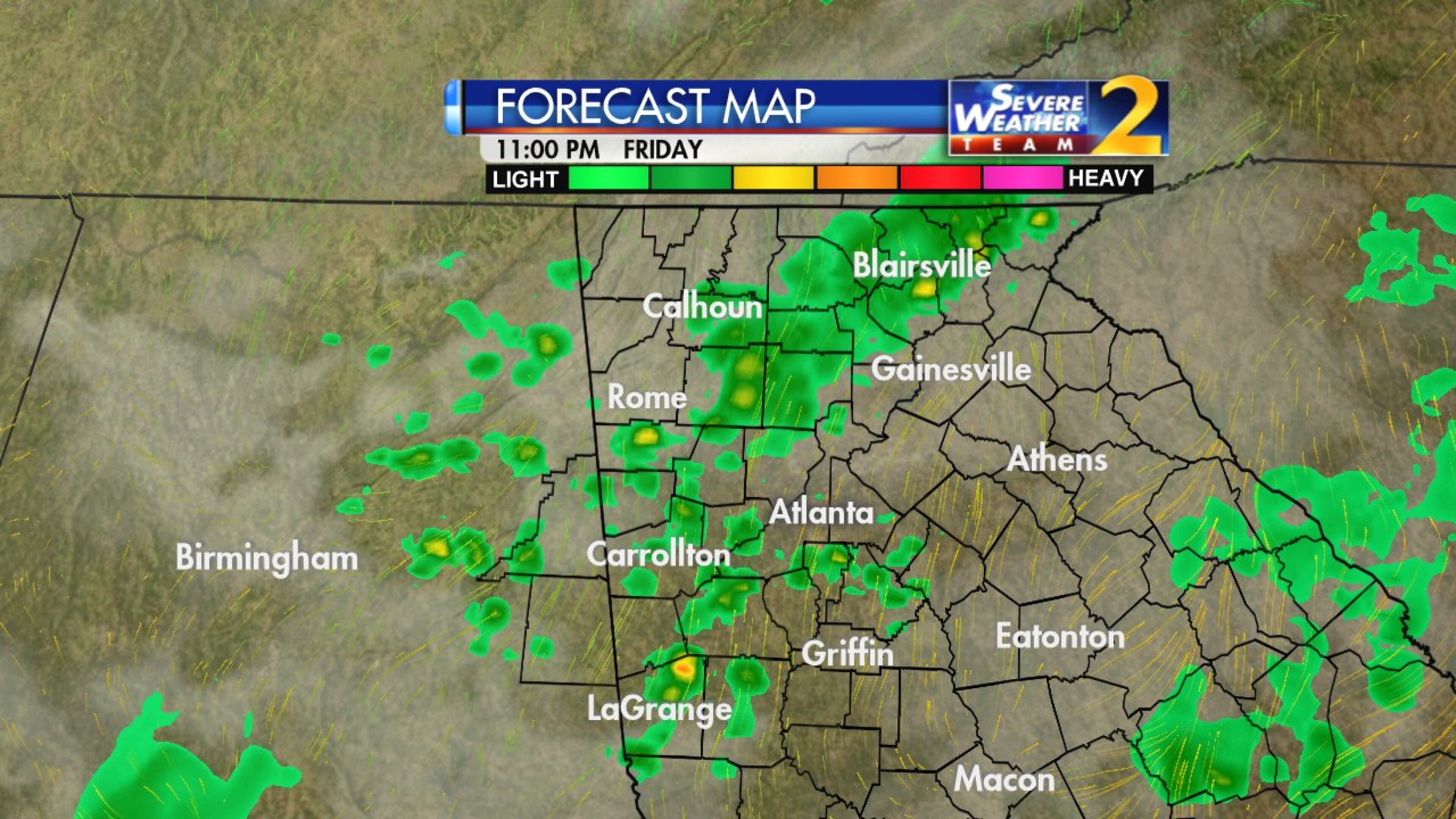
Channel 2 meteorologist Katie Walls expects rain to continue in North Georgia this evening, but the showers should be much less intense.
Storms' intensity will taper after sunset. That said, I'm still expecting a few showers (non-severe) on radar at 11. @BradNitzWSB will be tracking them on the #Nightbeat pic.twitter.com/sGLsEX3wQK
— Katie Walls (@KatieWallsWSB) June 22, 2018
[8:10 p.m.]: Georgia Power reports over 12,000 customers are without power after the worst of Friday's storms. There are 160 active outages, according to Georgia Power's Outage Map.
[7:47 p.m.]: Over 9,000 Georgia Power customers are without power because of the weather today. There are 152 active outages, according to Georgia Power's Outage Map.
[7:28 p.m.]: New and extended thunderstorm warnings have been issued for Clayton, Fayette, Henry, Newton, Rockdale, Butts and Spalding counties until 8:15 p.m. by the NWS.
Channel 2 Action News meteorologist Katie Walls said the storms should taper off in intensity after sunset, but they will continue into the evening.
[7:08 p.m.]: Channel 2 Action News meteorologist Katie Walls said conditions are improving in Cobb County, which is good news for Braves fans attending their 7:45 p.m. game against the Baltimore Orioles at SunTrust Park.
I am optimistic @Braves fans! Conditions are improving for Cobb and will do so through the evening. A few showers are possible later tonight but the lightning threat is winding down. (Maybe take a towel to wipe down the seats?) Enjoy! https://t.co/uaf49r9V1d
— Katie Walls (@KatieWallsWSB) June 22, 2018
[7:06 p.m.]: The Braves announced that their 7:35 p.m. game against the Baltimore Orioles has been delayed 10 minutes because of the weather.
Due to earlier rain, the start of tonight’s game will be delayed until 7:45. pic.twitter.com/Q9J4kwClo2
— Atlanta Braves (@Braves) June 22, 2018
[6:57 p.m.]: Severe thunderstorm warnings were added or extended for Forsyth, Coweta, Heard, Lamar, Meriwether, Pike and Spalding counties until 7:30 p.m. by the NWS.
Severe Thunderstorm Warning including Peachtree City GA, Newnan GA, Griffin GA until 7:30 PM EDT pic.twitter.com/oRMPCtLdOw
— NWS Atlanta (@NWSAtlanta) June 22, 2018
Damaging wind gusts, heavy rain, and lightning for the south metro over the next hour. pic.twitter.com/WPQvnJB1Fb
— Brad Nitz (@BradNitzWSB) June 22, 2018
[6:45 p.m.]: Georgia Power reports 136 outages across Georgia, mostly in the metro Atlanta area. Over 4,000 customers are without power, according to Georgia Power's Outage Map.
[6:37 p.m.]: Storms have moved mostly to northeast Georgia and the southwest metro Atlanta area, Channel 2 Action News Brian Manahan said.
Strong storms rolling across north Georgia now with a history of strong wind. @BradNitzWSB and @KatieWallsWSB tracking live now pic.twitter.com/Heeqnv7bxQ
— Brian Monahan, WSB (@BMonahanWSB) June 22, 2018
[6:32 p.m.] The city of Milton tweeted that trees have been knocked down on Freemanville Road due to the storms, blocking it for at least the next two hours.
Weather/Traffic Alert: Evening storms have downed a number of trees across #MiltonGa. 14660 Freemanville Road completely blocked. Hope to have road reopened in 2-2.5 hrs. Drivers navigate carefully--trees & road crews in the roadway. Please RT.
— City of Milton (@cityofmiltonga) June 22, 2018
[6:19 p.m.] Severe thunderstorm warnings for Hall and Lumpkin counties were extended until 6:45, NWS said.
Coweta, Troup and Meriwether counties are also under severe thunderstorm warnings until 7 p.m., NWS said.
SEVERE THUNDERSTORM WARNING in effect for Troup, Meriwether, Coweta until 7pm for 60 mph winds, <.75" hail pic.twitter.com/0Z4o4WHu25
— Katie Walls (@KatieWallsWSB) June 22, 2018
[6:14 p.m.]: Multiple trees have blocked a section of Whitlock Avenue in front of the Winnwood Retirement Community, Channel 2 Action News reported.

[6:09 p.m.]: MARTA's red line is experiencing 15 minute delays due to a previous mechanical issue, MARTA tweeted.
Due to a previous mechanical issue with a NB Red line train at Garnett, delay occurring on the N/S line, approximately 15 minutes.
— MARTA (@MARTASERVICE) June 22, 2018
[6:06 p.m.]: Damages have been reported in Alpharetta, including downed trees and power outages, according to Channel 2 Action News.
Wind Damage in Alpharetta #StormWatchOn2 https://t.co/pF9LCZm3fd
— Katie Walls (@KatieWallsWSB) June 22, 2018
[6:01 p.m.]: Clayton, DeKalb, Douglas and Fulton counties are under severe thunderstorm warnings until 6:45 p.m., the NWS said.
The severe thunderstorm warnings for Dawson, Hall and Lumpkin counties were extended to 6:15 p.m. by the NWS.
Severe Thunderstorm Warning including Atlanta GA, East Point GA, Union City GA until 6:45 PM EDT pic.twitter.com/dgbEDlLEwI
— NWS Atlanta (@NWSAtlanta) June 22, 2018
[5:48 p.m.]: Some trees and power lines are reportedly down on multiple roadways in southwest Forsyth County, according to a tweet from the Forsyth County Sheriff's Office.
Castleberry Road, Valley Stream Drive and Post Road at Derby Trail have all been closed due to the weather, the tweet said.
***WEATHER/TRAFFIC ALERT***
— ForsythCountySO (@ForsythCountySO) June 22, 2018
FCSO has trees and power lines down on the following roadways in southwest Forsyth.
Valley Stream Drive
Post Road at Derby Trail is CLOSED
Majors Road near Castleberry Road
Use extreme caution while driving.
[5:43 p.m.]: Cobb, Douglas and Fulton counties are under severe thunderstorm warnings until 6 p.m., the NWS said. Dawson, Forsyth, Hall and Lumpkin counties are under severe thunderstorm warnings until 6:15 p.m., the NWS said.
Cherokee County’s thunderstorm warning expires at 5:45 p.m. Gwinnett County and North Fulton County’s thunderstorm warning was cancelled before it’s expected 5:45 p.m. expiration time.
North Fulton now OUT of the Severe Thunderstorm Warning. Still in effect for eastern Cherokee, Forsyth til 5:45 pic.twitter.com/yI352NjQkL
— Katie Walls (@KatieWallsWSB) June 22, 2018
UPDATE [5:18 p.m.]: The National Weather Service has issued severe thunderstorm warnings for Cherokee, Forsyth, Fulton, Gwinnett and Hall counties until 5:45 p.m.
Severe thunderstorm warning until 5:45 pm for this storm in north Fulton moving ENE. 60+ mph gusts possible. pic.twitter.com/OyP55yC5A9
— Brad Nitz (@BradNitzWSB) June 22, 2018
ORIGINAL STORY: A wave of thunderstorms has reached west Georgia and is entering metro Atlanta just in time for the evening commute.
Atlanta previously reached a steamy 90 degrees, which is two degrees hotter than predicted. That doesn’t bode well for these approaching storms, since all that hot air will act as fuel, Channel 2 Action News reported.
Storms are moving into metro Atlanta now. I'll be tracking these with @katiewallswsb on @wsbtv at 5pm. pic.twitter.com/tKCDotmIxB
— Brad Nitz (@BradNitzWSB) June 22, 2018
Construction on the Downtown Connector is also causing heavy delays, and traffic is stop-and-go around the Perimeter as well, according to the WSB 24-hour Traffic Center.
Peachtree Road southbound near Palisades Road has two lanes closed due to construction and one lane closed northbound near Deering Road, the Traffic Center reported.
I-75 North near Jonesboro Road is experiencing heavy delays up to 30 minutes due to a crash in the left lane, the Traffic Center reported.
This has cleared, but still 30 min delays. Use Hwy. 42. #TRAVELADVISORY #ATLtraffic https://t.co/2hvjWkI3bV https://t.co/tGTaKHFrFe
— AJC WSB Traffic (@ajcwsbtraffic) June 22, 2018
Only one left lane is open on I-20 eastbound near Martin Luther King Drive after a vehicle fire, according to the Traffic Center.
#GRIDLOCKALERT west Atlanta: I-20/eb at MLK (Exit 53), only left lane open for auto flambe cleanup. Use Hollowell. #ATLtraffic https://t.co/2hvjWkI3bV pic.twitter.com/HAJKBNX8HF
— AJC WSB Traffic (@ajcwsbtraffic) June 22, 2018
Roadwork is also scheduled until Saturday on Memorial Drive, between Pearl Street and Chester Avenue, the Georgia Department of Transportation said. Repairs to two sinkholes on Venture Drive in Gwinnett County are still underway. The road is closed between Steve Reynolds Boulevard and Pleasant Hill Road, which is located near Gwinnett Place Mall in Duluth.
MORE: Sinkholes near Gwinnett Place Mall close street for second day
There’s also familiar construction in the right lane on Peachtree Road at Pharr Road in Buckhead that’s causing some delays, the Traffic Center reported.
Fulton Co.: Construction: Peachtree Rd./nb at Pharr Rd.; in the right lane; delays; https://t.co/RuPa64SzPC; #ATLTraffic pic.twitter.com/3B6y2nKn0N
— Triple Team Traffic (@WSBTraffic) June 22, 2018
The storms on the way could dump as much as 2 inches of rain in some areas.
Northwest Georgia has the greatest risk of scattered severe storms, while showers are expected to be more isolated for metro Atlanta, according to Channel 2.
A weak disturbance in Alabama and a low over the Midwest should give storms energy to develop.
Today is another day to be Weather Aware! Some storms this afternoon will be strong or severe. The best likelihood for stronger storms is in orange. I'm updating the time-line for when storms develop in your neighborhood at Noon on Ch. 2 Action News. #gawx pic.twitter.com/MUL4yABQjB
— Katie Walls (@KatieWallsWSB) June 22, 2018
The wet weather is projected to appear first on the Westside before becoming more widespread, Walls said.

Minton said a cold front will move in through the weekend to bring temperatures down a few degrees. There’s now a 60 percent chance of storms on Saturday and a 20 percent chance on Sunday.
Before the rain and storms begin today the temperatures will reach the upper 80s. A few low 90s are possible east of Atlanta. pic.twitter.com/QOGzeThVPQ
— Karen Minton (@KarenMintonWSB) June 22, 2018
“We’ll continue with another chance tomorrow afternoon, too,” Minton said. “We'll be drier in the morning, so morning activities are OK. (But for) afternoon activities, you're dodging storms and then mainly dry on Sunday.”
More showers and storms today and Saturday, then a mostly dry Sunday. However, the overall trend is a wetter than normal end of June into the first few days of July. pic.twitter.com/yKMemGYBNy
— Karen Minton (@KarenMintonWSB) June 22, 2018
The rain on Friday could affect the Braves’ game against the Baltimore Orioles at 7:35 p.m. at SunTrust Park. At the very least, traffic should be worse nearby leading up to first pitch.
» For updated traffic information, listen to News 95.5 and AM 750 WSB and follow @ajcwsbtraffic on Twitter.
» Download The Atlanta Journal-Constitution app for weather alerts on-the-go.
About the Authors

Zachary Hansen, a Georgia native, covers economic development and commercial real estate for the AJC. He's been with the newspaper since 2018 and enjoys diving into complex stories that affect people's lives.


