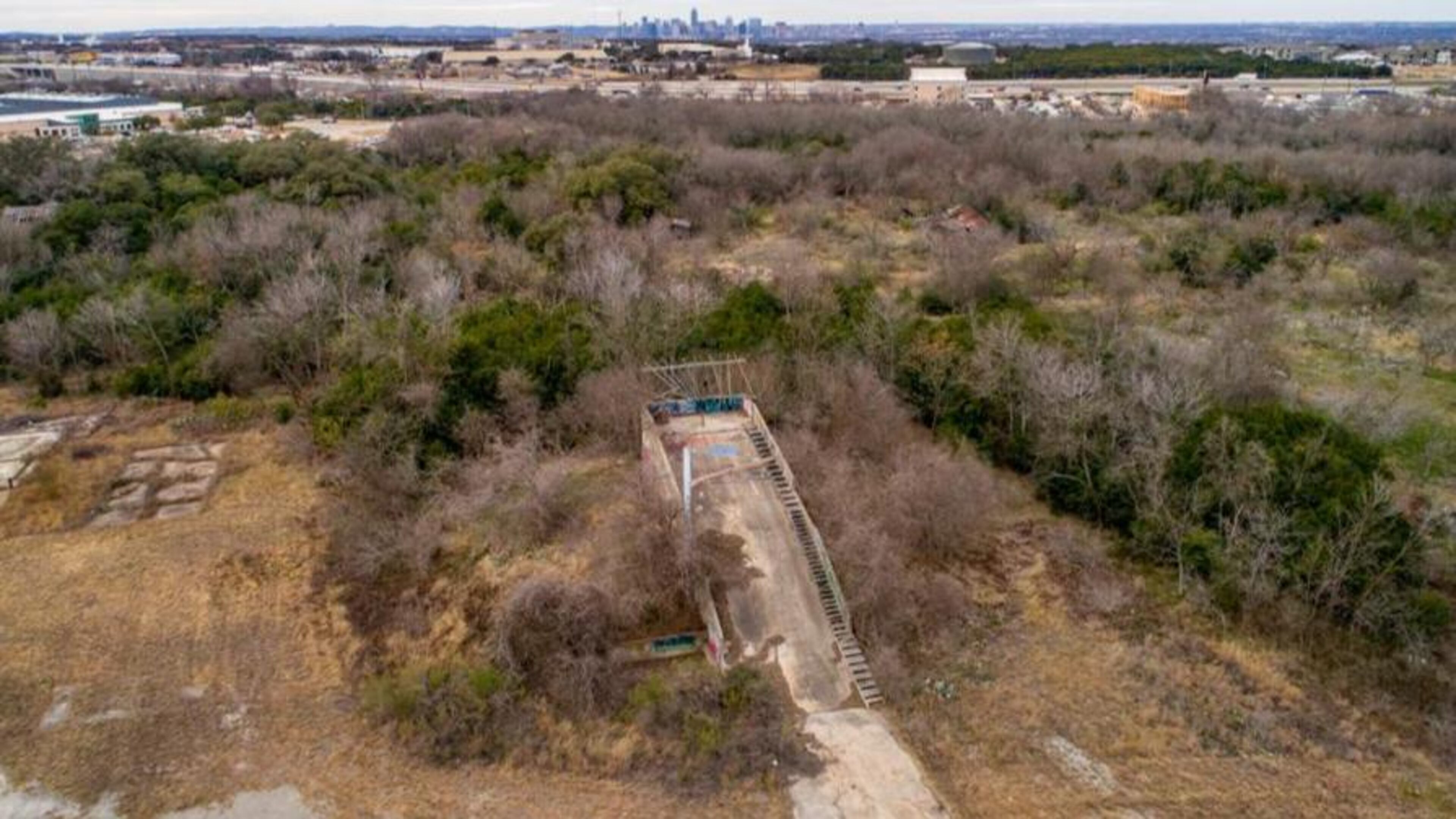
‘Ramp of Mystery’ in middle of nowhere was drone test site

If you search on Google Maps for "Ramp of Mystery," a curious Southeast Austin landmark appears. It's a concrete structure that leads to nowhere, sitting in an overgrown field.
It’s a steep ramp with too much of an incline to walk up easily. To the side, an aging and precarious set of wooden steps goes up to the top, where the path that led to the ramp leads to nothing -- just a steep dropoff over a short boundary and lots of graffiti all around the structure.
The ramp has been the subject of lots of online speculation, especially since it became the subject of a Reddit thread in late 2016. Was it part of an old military project, this thing off an office park at 6900 Metropolis Drive? A structure that once connected to a shipping dock? A base for gravel dumping? A piece of a road that once connected to East Ben White Boulevard? What was this thing?
Adam van Alderwerelt, an Austin lighting designer and video engineer, became a bit obsessed with the ramp after volunteering at a nearby building that housed evacuees from Hurricane Harvey.
“Nobody at the shelter even knew what it was,” he said. “I only saw it because it was on Google Maps when I was looking for directions to and from the shelter.”
Van Alderwerelt shot a YouTube video, "What is South Austin's Ramp of Mystery??"
“I thought, let’s bring some awareness to this thing,” van Alderwerelt said. “It’s a hidden oddity of Austin.”
The buzz around this curious structure prompted a reader to ask our Austin Answered project: “Please tell us about the Ramp of Mystery in South Austin; Google it!”
We did. But the ramp didn't divulge its origin so easily. Visits to the Austin History Center to study old aerial photographs of the area proved inconclusive, except to show that it probably didn't originate before the early 1980s. A wide call on social media for any local insight on the landmark yielded a few leads, but nothing concrete, so to speak. The current owners of the lot, Zydeco Development Corporation, said by phone they didn't know what the ramp was for or why it was built.
A request to Lockheed Martin, which owned a facility in the area that opened to much fanfare in the 1980s, was unsuccessful. The company checked but was unable to find records related to the ramp or its purpose.
But leave it to a historian to crack the case.
Austin history buff Lanny Ottosen tracked down names on an old document related to the property he found at the Austin History Center. One of those names was Frank Niendorff, who for many years ran Commercial Industrial Properties Co. (also known as NAI Austin).
Niendorff, who spent two years brokering the property deal to bring Lockheed Missiles and Space to Austin (for one year, the identity of the buyer was a secret even to him), remembered the ramp well.
“There’s nothing mysterious about the ramp,” he said this week by phone, “When Lockheed first came here, they were working on developing a government contract for a drone. This was when drones were first imagined. This was a drone that would be launched from a ramp.”
The program, called "Aquila," involved hydraulic catapults to launch the drone and a net that would catch the unmanned aerial vehicles. The drones would be used to provide laser guidance for weapons systems.
The San Diego Air and Space Museum has archive footage on YouTube of what appears to be such a system.
Despite the work Lockheed did with the drone project on that ramp, Niendorff said, the government bid was unsuccessful.
“They spent millions of dollars trying to get this contract, building prototypes,” he said. “Ultimately, Lockheed ended up building other things at that facility, including concrete bunker bombs.”
Kenneth Ross, a spokesman for Lockheed, said that as far as the ramp goes, Niendorff appears to have the right information.
“The info you’ve discovered gives us confidence that you have the right story,” Ross wrote in an email.
When informed of the drone-based answer to the question he’d been asking, van Alderwerelt said by phone Friday, “That’s amazing! I never would have thought of that.”

