WEATHER-TRAFFIC UPDATE: Sprinkles continue into evening commute, congesting interstates
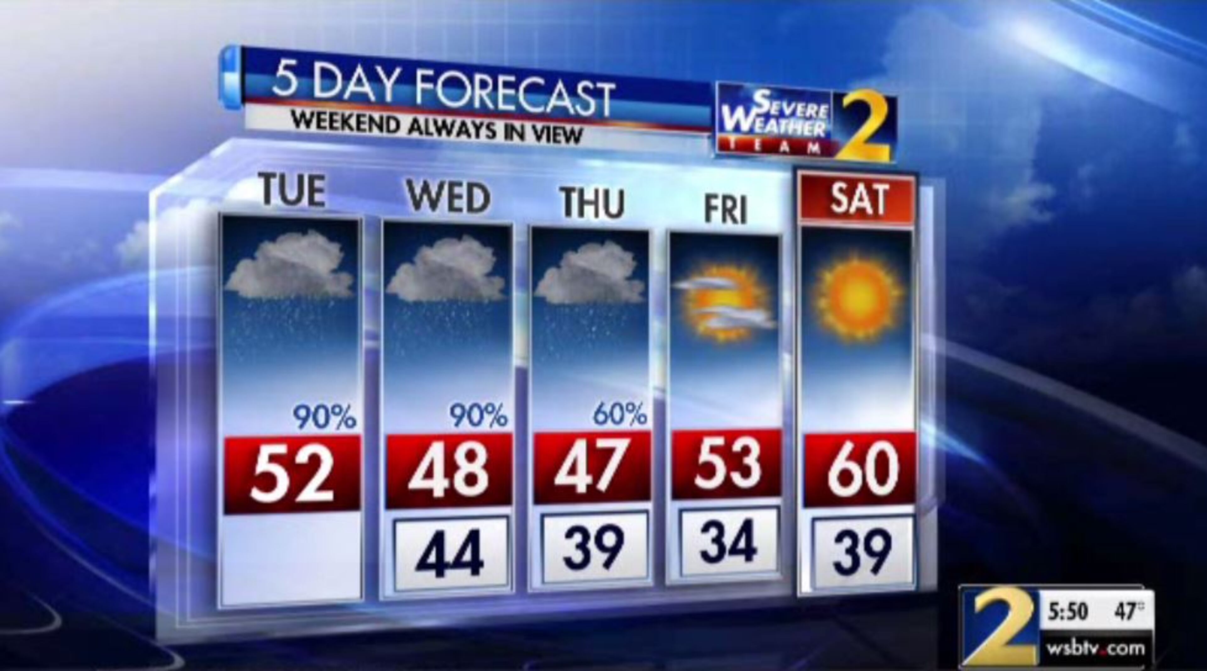
ATLANTA FORECAST
Tuesday: High: 51
Tuesday night: Low: 45
Wednesday: High: 48
» For a detailed forecast, visit The Atlanta Journal-Constitution weather page.
Sprinkles continue across North Georgia as the evening commute ramps up, meaning that roads aren’t soaked, but they aren’t dry, either.
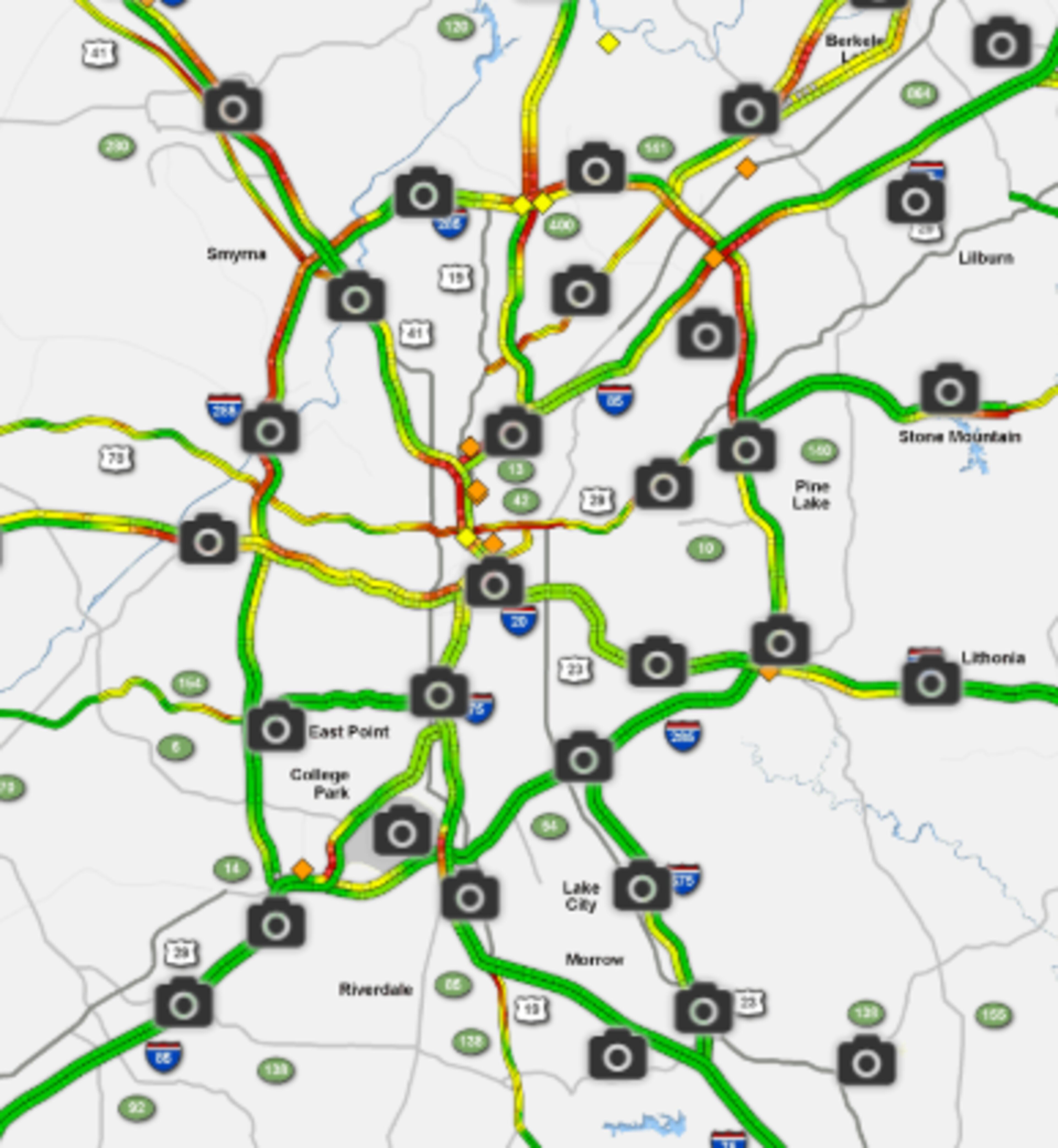
There aren't many notable wrecks in Atlanta at the moment, but congestion is picking up as people begin the trek home, according to the WSB 24-hour Traffic Center.
Road closures because of active flooding or water damage also continue Tuesday afternoon.
In Fulton, Azalea Drive remains shut down from Atlanta Street to Willeo Road and from Willeo Road to the Cobb County line.
Live@630am Rowell police blocked Azalea Dr because of flooding we’re live where the water receded #wsbtv pic.twitter.com/PMD7spDHlD
— Darryn Moore (@DarrynMooreWSB) November 13, 2018
Mount Vernon Road is closed between Skyview Drive and Park Drive at Woodrow Wilson Park in Lithia Springs, authorities said.
All that rain caused some smelly problems for DeKalb County. The county reported five sewer spills into waterways Monday, most of them coming from overwhelmed manholes.
MORE: Storms cause five 'major' sewer spills into DeKalb waterways
Several inches of rain fell Monday, according to Channel 2 Action News, with Atlanta getting 5 inches and the northwest suburbs seeing 6 inches.
FLASH FLOOD WATCH has been issued for Wednesday into Thursday AM.
— Brad Nitz (@BradNitzWSB) November 13, 2018
An additional 2-3" of rain is possible as heavy rain moves in tomorrow and falls on a saturated ground. Many creeks and and rivers are already at minor flood stage and will rise tomorrow. pic.twitter.com/b8EGVpS2u0
The soaked ground prompted the National Weather Service to issue a flash flood watch for metro Atlanta, Middle Georgia and North Georgia from Tuesday night until 7 a.m. Thursday.
North Georgia could get another half-inch of rain before Tuesday is over, Channel 2 meteorologist Brad Nitz said.
Flood Watch in dark green, river flood warnings in light green. Last round heaviest was NW next round heaviest SE #ATLweather #gawx #ATLTraffic #ATL #Atlanta pic.twitter.com/zlcvTqY66n
— Kirk Mellish (@MellishMeterWSB) November 13, 2018
Bloated rivers and creeks were reported in several metro Atlanta counties from Cobb to Gwinnett, prompting the Weather Service to issue flood warnings in those areas.
A flood warning means flooding is imminent or occurring. The warnings include Sweetwater Creek near Austell, Big Creek near Alpharetta, and Suwanee Creek near Suwanee.
The warning for Cobb and Douglas counties is set to expire Wednesday morning, but the Weather Service says additional rainfall could change that forecast. All other warnings are in effect until further notice.
The rain is expected to taper off into the evening, according to Channel 2. Temperatures should not vary much through the day, hovering in the lower 50s.
STILL CHILLY: Staying chilly today, though a bit warmer than yesterday with less rain. Highs will be in the 40s to the low to mid 50s.
— Brian Monahan, WSB (@BMonahanWSB) November 13, 2018
Another round of heavy rain is coming later tomorrow. @BradNitzWSB is updating the forecast at noon on Ch. 2. pic.twitter.com/NcprwaMFvY
Another round of heavy rain is expected Wednesday when a fresh area of low pressure developing along the Gulf Coast pushes across the state.
The most rain should fall southeast of Atlanta from Eatonton to Athens, Channel 2 meteorologist Karen Minton said. That area can expect another 2 to 4 inches. While it will be lighter to the northwest, she predicts Atlanta will get another 1 to 2 inches before it’s all done.
Flood threat likely to increase Wednesday-Thursday.
— Brad Nitz (@BradNitzWSB) November 13, 2018
Showers today plus heavy rain Wednesday through Thursday morning will bring an additional 1-2" in metro Atlanta, 2-4" to the east. pic.twitter.com/HW4GkcwymD
Thursday should be another rainy day before clouds start clearing out Friday, according to the latest forecast from Channel 2.
“On Friday, we're looking at sunshine taking over,” Minton said. “It will be cold in the morning, cool in the afternoon, warming over our weekend.”
For Saturday and Sunday, temperatures are still expected to be below average, but “it won’t be raining,” she said.
» For updated traffic information, listen to News 95.5 and AM 750 WSB and follow @ajcwsbtraffic on Twitter.
» Download The Atlanta Journal-Constitution app for weather alerts on-the-go.
About the Authors


Zachary Hansen, a Georgia native, covers economic development and commercial real estate for the AJC. He's been with the newspaper since 2018 and enjoys diving into complex stories that affect people's lives.